Day 3: A walk by the lake
19 February 2007
12:00 AM
Torres del Paine — Day 3
February 2, 2007
I woke up and started the third day with my routine. Get dressed. Use same clothes from yesterday. Dust feet with talcum powder. Apply to socks too. Gotta keep these workhorses happy. Boil water for oatmeal and coffee. Stuff sleeping bag into sack. Roll sleeping pad. Eat. Wash dishes. Take down tent. Start hiking. The whole process sounds mechanical and short, but it took a surprising amount of time. Today, for example, Amanda and I woke up at 8:30 and it took us two full hours to run through the tasks.
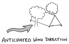
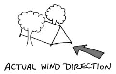
At least today, our sluggishness could be attributed to a poor night’s sleep. The night before, we had pitched our tent strategically in the narrow space between two trees. They would shield us from the Patagonian wind, we thought. The wind didn’t cooperate. Instead of blowing parallel to our protective tree line, it changed direction and blew directly into our tent. All night long. I had a nightmare—not unfounded—in which the wind ripped off our tent’s protective layer. At three o’clock in the morning I sat bolt upright. “The rainfly!” I shouted, looking desperately out the tent window to see if it was still there. It was, but that gives you some idea of the kind of night we had.
Rapidly passing hours wasn’t the only time anomaly, either. I was already losing track of the day of the week. I knew that it was day three, but I hadn’t the foggiest idea if that was Tuesday or Friday. In my book, that’s a successful vacation.
At 10:30 we left camp. Our route for the day was ten miles long, practically all of which followed the northern shoreline of Lake Nordenskjöld. We would do the first seven miles and then break for lunch. Shortly after we hit the trail heading west, I started questioning our itinerary. Here we were with days left in Torres del Paine National Park, and we had already seen the Torres del Paine. Would it just be downhill from here? Of course not literally—that would be quite the blessing—but would there be any highlights left on the trail? What was left to see? Maybe it would have been better to start at the other side of the W and go east. That way we would have saved the park’s namesake for last. You know, we could have gone out with a bang.

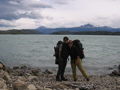
There was so much time to think as we hiked on the trail that I quickly moved on to other topics. For one, I thought about the bag on my back. Backpacking requires lots of specialized gear and major companies compete to make equipment better and lighter. These companies aren’t shy about letting you know what gear is theirs either. Logos cover everything. When I envisioned myself on the trail, I felt like a human NASCAR vehicle plastered with corporate sponsorships. I had a Kelty backpack with a CamelBack water pouch. My daily uniform was Eastern Mountain Sports zip-off pants and a Hind shirt (which gets my vote for best slogan: “Making sweat look good,” and they did). When it got cold I wore a Patagonia jacket on top of a North Face fleece and an Orvis vest. At night I slept in an REI sleeping bag on a ThermaRest pad in an REI tent. We cooked our food over a Doite stove. I used a Black Diamond headlamp. My feet in particular brought in big sponsor bucks. I wore SmartWool Seriously Comfortable Hiking Socks, and alternated between Chaco sandals and Lowa boots with Gore-Tex lining and Vibram soles. The most notable difference between me and NASCAR vehicles, discounting top speed, is that I paid for my sponsorships instead of earning money from them.
Gear isn’t cheap, but Amanda and I had used a few tricks to reduce acquisition cost. I didn’t own any hiking clothing, so instead of buying it I just had Amanda bring some of my dad’s. We needed a tent, and Amanda, together with some friends, had given one as a joint wedding gift some months ago. She asked to borrow her gift and we were set. Our stove and pot we rented for $2 a day.
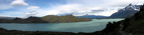
Panorama of Lake Nordenskjöld
I got lost in thought. When I found myself again, I realized I had some serious scenery gazing to do. This was spectacular, and so different from the day before. Our path along the northern edge of the unpronounceable Lake Nordenskjöld gave quite the view. The lake was a pale blue, unlike any I had ever seen before. Fast-moving clouds overhead cast shadows on the lake’s smooth surface. As we rounded a corner I caught sight of the Cuernos del Paine, the Paine Horns. This is another one of the landmark sights in the park. The horns are two granite peaks, white with a sharply defined black upper layer, that look as advertised: like a pair of horns on the hill. Beyond the Cuernos was a glacier-encrusted mountain. Taken together, I had a saturated Technicolor view of nature’s palette: the pale blue of Nordenskjöld, the vivid green hill to the south, the white snow, the light gray and black granite of the Cuernos, the icy blue of the glaciers, vibrant red berries, and the dirts, which ranged from black to the rich brown of coffee mixed with milk. Seeing such chromatic variety at one time was overwhelming. If yesterday’s exhibit-on-display was the weather’s force, today’s was color and the sheer variety of natural formations.
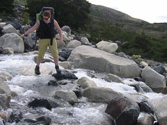
The mountains on our right sloped downward to Nordenskjöld on our left. Dozens of glacier-fed streams ran towards the lake. We had to cross a number of them, ranging from the simple, crossed with a well-placed step and a leap, to the more complicated, which required advance planning and looking for the next few steps. My slipshod planning at some streams made me thankful that my shoes were Gore-Tex lined. Even so, water entered at my ankles a couple times.

Panorama of the Cuernos del Paine
Every few steps I saw our surroundings with new, awe-struck eyes and took a photograph. The Cuernos from a minutely different angle? Better take a picture. A twisted tree? Better take three. Lake Nordenskjöld, which had been on our left-hand side for four hours and would continue to be there at least another hour still: picture. Berries, flowers, a stream: snap, snap, snap. Miraculously, we still made good time and covered the first seven miles within the four hour estimate the map gave. We arrived at the Cuernos rest point, located at the base of the horns, just in time for our sandwich lunch.
Torres del Paine isn’t untouched wildness in all areas, technically speaking. The trail system is well developed. You can get from site to site without a map, although you might be caught off guard by those wily contour lines. Moreover, the rest points are at times outrageously equipped. Many have lodging, cooking facilities, meals for purchase, toilets, even hot showers. The result is a park that caters to several tiers of clientele. People visiting Torres del Paine in the top tier stay at fully equipped hotels found at a few major points on the trail, like Hostería Las Torres or Hostería Lago Grey. These start at $170 a night for a basic single and rise to $300 a night for a fancy double. These same places offer dinner for $40 and lunch for $33. Moving down the list, at the second tier, there are many refuges along the trail with shared bunks for $40 a night and meals for $13. Down at tier three there are serviced campsites which cost $7 a night per person. Amanda and I avoided those for the most part because we were in tier four, comprised of the people who sought out the free, unserviced campsites at select points along the trail. It was for that reason that we were continuing after lunch from Cuernos, a pay site, to Italiano, a free one. Also, there appeared to be an inverse relationship on the trail between wealth and backpack size. Big rollers in the park traveled with tiny packs and rented what they needed at waypoints, everything from tents to stoves. Unsurprisingly, our packs were large.
The trail class system didn’t bother me. In fact, I thought it was fantastic that there were different levels of access to the park. I figure if I came back later in life, I’d move up at least to a couple nights in the refuges. For the most part, though, we didn’t cross paths with the people in tiers far above us. Humor ensued when we did. At one stop we ran into a woman who asked us to describe the trail we hiked the day before. We told her that it was up-and-down for about ten miles and took us seven hours to cover. “Oh,” she reacted. “I suppose I’ll see if I can’t get a horse then.”
As we made our way towards Campamento Italiano, our pace slowed. The undulating trail sloped mercifully downhill, only to rise up again. We descended to Lake Nordenskjöld and touched the waters. Then, faced with a particularly arduous uphill climb, I said to Amanda, “I’m not stopping until the top. If I do I won’t start again.” It was a hot day—we wore T-shirts and shorts—which didn’t help matters. I finally rose over the last hill and turned the bend, only to find that it merely appeared to be the last hill; another one sat in front of me. “Does it ever end?” I screamed at the mountain. From behind me I heard Amanda’s faint voice, “Don’t say that!” Before long, we found ourselves a few hundred feet above the lake.
Our pace was further slowed by my addiction. Every several paces Amanda would hear the tell-tale sound of Velcro ripping apart as I opened my camera case to take another shot. “I think this is my last one for awhile,” I would tell her. “Then I’ll just appreciate it with my eyes.” But time after time as we took in the landscape I felt compelled to take pictures, almost more in awed homage to the scenery than to capture the view. I knew the results wouldn’t show people back home what I was seeing, but taking pictures was a reflex when faced with such beauty. In the end it was only my limited battery that convinced me to stop.
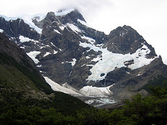
Near the end of our day’s route we veered north, away from the lake and into the French Valley. Suddenly we found ourselves in a darker place. The gray Great Paine mountain that had been foreboding from a distance now overshadowed us. The Paine’s main peak is 10,160 feet high, which may not be tall in absolute terms, but the pinnacle was only three miles away and we were standing at a mere 600 feet above sea level. The difference was enough to push your head back in wonder. The French Glacier rode on the mountain’s ridge and scattered ice patches gave it a war-torn look.
Not long after, we reached Campamento Italiano, where we set up camp and spent the next few hours chatting with other travelers. Three men, from England, Ireland, and Australia, were on their last day of the complete park circuit and they had plenty of advice on what to see and how to do it. When it was dark, Amanda and I collapsed into our tent. A long day on the trail and a site protected from the wind made for a sound night’s sleep. As I fell asleep I decided I had been a bit quick to want to revise our itinerary in the morning. Based on what I saw today, it was clear the trail still had plenty in store.
Continue reading tomorrow to find out about one unexpected surprise that the French Valley had in store for us.

Comments